
SMARTIES - Supercritical fluids and MAgma Reconnaissance for Transformative Iceland Energy Solutions


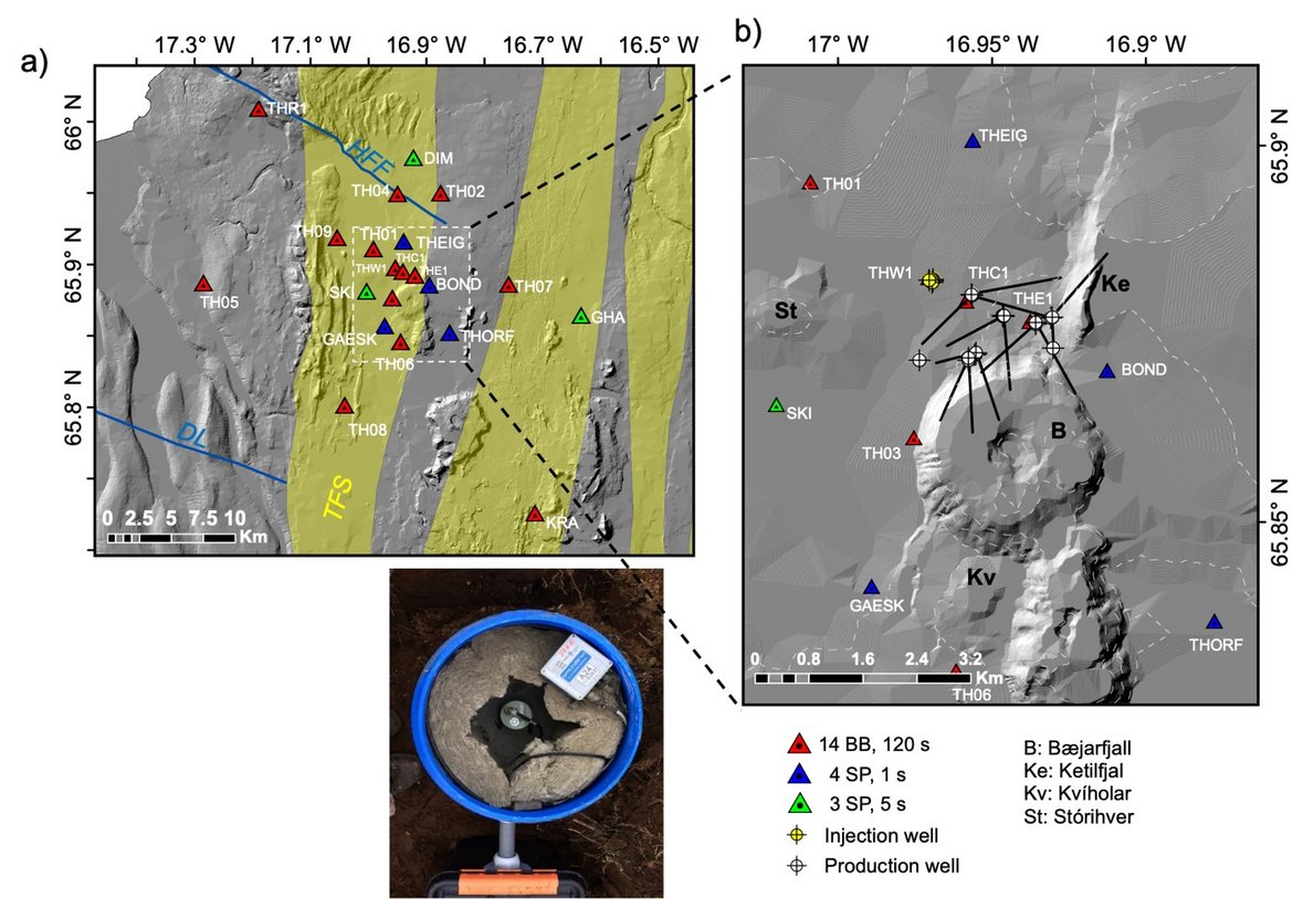
Red broken lines show the spreading zones of the MAR, thin black broken lines show central volcanoes, and yellow areas indicate fissure swarms. The lineaments GOR (Grìmsey Oblique-Rift), HFF (HÃsavìk-Flatey Fault), and DL (Dalvìk Lineament) of the TFZ (TjÃrnes Fracture Zone) are shown with blue lines. The TFS (Theistareykir fissure swarm) of the NRZ (Northern Rift Zone) is indicated with yellow letters. b) Temporary (red triangles) and permanent (blue and green triangles) seismic networks at the Theistareykir geothermal field. The location of panel c) is shown with white dashed lines. The yellow dashed lines indicate the region shown in Figure 7. The HFF and DL are shown with blue lines, and the fissures swarms are indicated as yellow areas. c) Main exploitation area. The location of injection and production wells are marked with yellow and white circles, respectively. Approximate well deviations are shown as black lines – adapted from Toledo et al., 2021. (GFZ)
Contact
GFZ Websites
Data Access via
Infrastructure belongs to
Recognizing that the exploration and harnessing of magmatic and geothermal reservoirs involves many disciplines, the mission of “SMARTIES” is to implement a long-term observatory facility together with episodic field experiments for defining, testing and validating an interdisciplinary reservoir assessment approach, based on observations and modelling. SMARTIES addresses three key questions:
-
How can we observe and model the structure and dynamics of magmatic/hydrothermal systems and their transition zone to assess potential volcanic hazards and quantify the geothermal potential?
-
How can we monitor and better understand the interactions between reservoirs, faults and earthquakes, and the environment, with particular emphasis on better understanding bidirectional and cascading processes?
-
How can we characterize and model processes of mass and energy transfer within supercritical and "superhot" hydrothermal reservoirs under natural and anthropogenic forcing?
The design of appropriate strategies for the optimal quantification of reservoirs and harnessing of geothermal resources (heat and energy production) will enable energy sustainability through a better constrained model defining optimized resource management. The concept of "SMARTIES" implements an holistic approach by combining conventional and innovative data sets, innovative analysis and processing methods and modeling tools, aiming at an improved model of the magmatic/hydrothermal reservoir in its geodynamic environment. Iceland is the perfect target to implement such a strategy, with volcanic sites located along rift zones, such as:
Temporal evolution and change of reservoirs
The Krafla caldera (diameter 10-12 km; 110 ky ago) is still active ("Krafla fires" 1975-1984). A NW-SE elongated high-temperature geothermal system has been explored and developed over the last 50 years. 40 exploration, production and re-injection wells supply a 60 MWe (MW electrical power) geothermal power plant. The deepest wells at Krafla are approximately 2 km below sea level. Krafla (Iceland) is a high-enthalpy system that has been harnessed since the 1970s and where the presence of magma at shallow depths (2.1 km) has been known since 2009 (Elders et al., 2010). The transition between the magma and the hydrothermal system has supercritical conditions, which is the next frontier for geothermal research (Scott et al., 2015).
Fault control of reservoirs
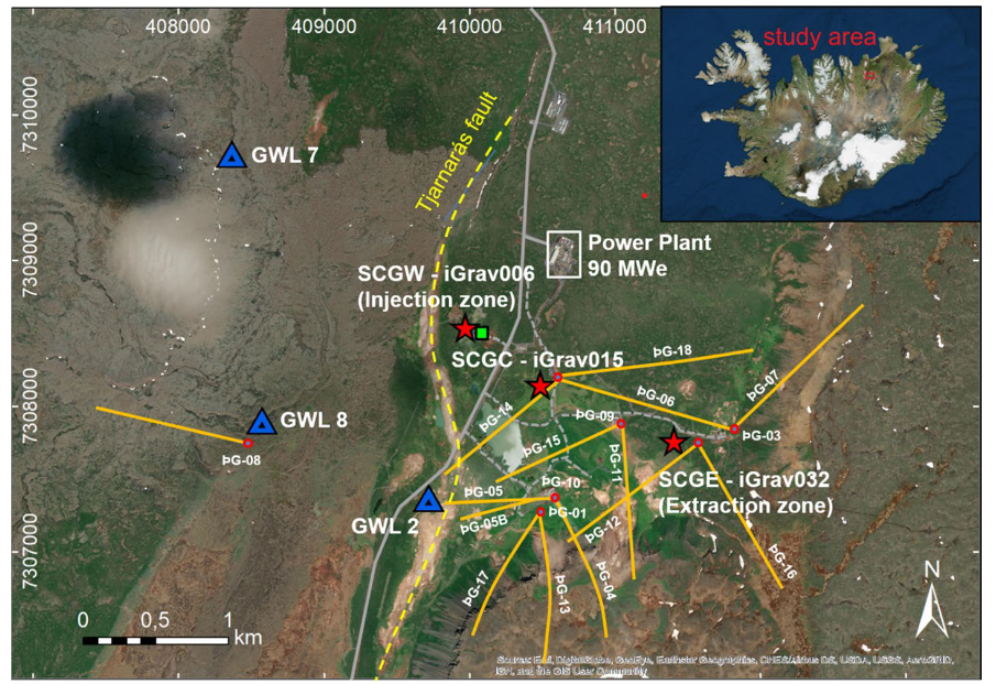
Þeistareykir (25 km northwest of Krafla) is unique due to the intersection of a N-S trending fissure swarm (diameter 7-8 km; length 70-80 km) with the WNW-ESE striking Húsavík-Flatey transform fault. Although explored over the last 50 years, production only started in 2017. 20 exploration, production and re-injection wells (<~2.2 km bsl) supply a 90 MWe geothermal power plant, with a 45 MWe expansion planned for the future. Þeistareykir (Iceland) is a high-enthalpy system that has been exploited since 2017; much data has been and continues to be recorded, including innovative methods such as distributed fiber optic sensing (Jousset et al., 2018), which is currently being recorded (2023), and continuous multi-parameter gravity stations (Forster et al., 2021). Complementary and accessible fault systems are located along the Reykjanes Peninsula and the South Iceland Fault System, allowing close study of earthquakes in accessible locations and knowledge transfer, as well as comparison with Þeistareykir.
“SMARTIES” is aiming at maintaining long term observatory facilities (since 2017 and for at least the next 10 years) to allow GFZ researchers and students to perform research in data analysis and modelling for volcanology, geophysics, geodesy, geochemistry and geodynamics.
Categories
Disciplinary Keywords
Instrumentation
The mission of “SMARTIES” is to implement a long-term observatory facility together with episodic field experiments for defining, testing and validating an interdisciplinary reservoir assessment approach, based on observations and modelling. This includes the setup of innovative multi-parameter stations, including superconducting gravimeters, weather stations, traditional geodetic instrumentation such as GNSS and tiltmeters, seismic observations, thermal campaigns and infrared monitoring, and regular satellite radar and drone photogrammetric observations. Acquiring and updating a high resolution maps of faults, fault displacements and structural assessments, as well as fluid monitoring at thermal and cold springs and gas exhalation sites complement the interdisciplinary reservoir assessment approach.
Specifically the permanent sites are:
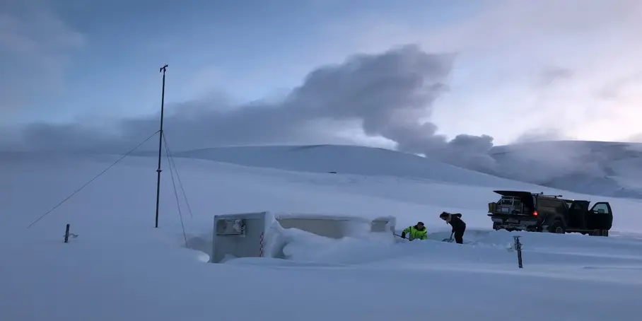
- 5 containers occupied by 2 iGrav superconducting gravity meters (GFZ) and 1 gPhone spring gravity meter (GFZ). (Embargoed until 2026-01-01)
- GNSS receivers, meteorological stations, 5 ROMPS system. (Embargoed until 2026-01-01)
- Network of broadband seismological stations (in collaboration with ISOR/Landsvirkjun) - https://geofon.gfz-potsdam.de/doi/network/3P/2017 (Embargoed until 2026-01-01)
Instruments
-
GNSS Receiver Assembly
The GNSS Receiver Assembly tracks the GNSS satellite ranging signals for satellite position and clock determination for on-board operations and precise absolute orbit determination and time-tagging of science data.
-
Gravity Meter